Where Is Vero Beach, Florida on the Map?
Where is Vero Beach, Florida on the map?
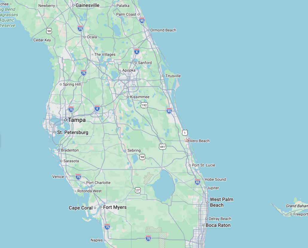
- Vero Beach sits on Florida’s Atlantic coast in Indian River County, about halfway between Orlando and Miami, at roughly 27.64° N, 80.39° W.
- On a map, look for the stretch of coastline known as the Treasure Coast, north of West Palm Beach and south of Melbourne. Vero is the county seat.
- The fastest way to find it driving is I-95 to Exit 147, then State Road 60 east straight into town and out to the beach.
- The town has two halves: the mainland and a barrier island, separated by the Indian River Lagoon. Where you land on that map changes your whole lifestyle and budget.
If you’re staring at a map of Florida trying to place Vero Beach, here’s the short version. Find the east coast, run your finger up from West Palm Beach about 65 miles, and stop before you hit Melbourne. That’s us. We’re on the Atlantic in Indian River County, roughly two hours either direction from Orlando and Miami, on the section of coast locals and tourism boards call the Treasure Coast.
I sell real estate here, so I get this question constantly from buyers up North who know they want Florida but can’t quite locate the specific spot they keep hearing about. Let me put it on the map properly.
The exact location
Vero Beach sits at about 27.64° N latitude and 80.39° W longitude. It’s the county seat of Indian River County, one of the smaller and quieter counties on Florida’s east coast.
Here’s how it lines up against the cities you already know:
- About 85 miles southeast of Orlando
- About 65 miles north of West Palm Beach, a 90 minute drive
- About 135 miles north of Miami
- About 15 miles north of Fort Pierce
- About 190 miles south of Jacksonville
So on a north-to-south read of the Atlantic coast, the order is Jacksonville, then Daytona, then Melbourne, then Vero Beach, then Fort Pierce, then West Palm Beach, then Miami. We’re tucked in that calmer middle stretch, far enough from the big metros to feel like a small town, close enough to reach two major airports in under two hours.
How to find it on a driving map
The cleanest way to orient yourself is by the highways.
I-95 runs north-south a few miles inland. To get into Vero Beach, you take Exit 147 for State Road 60. Head east on SR 60 and it carries you through the heart of the mainland, past the shopping corridor, and right up to the Indian River. There’s a fun bit of trivia in that road: SR 60 runs all the way across the state, so you can technically drive it coast to coast from Clearwater Beach on the Gulf to Vero Beach on the Atlantic.
US-1 is the older highway that runs north-south through the mainland part of town. It’s where a lot of the everyday Vero lives, the local businesses, the original downtown around the SR 60 intersection.
A1A is the scenic coastal road on the barrier island. If you’re picturing the postcard version of Vero, the beach, Ocean Drive, the oceanfront condos, that’s A1A.
The part most maps don’t show you: Vero is two towns
This is the thing I make sure every relocating buyer understands, because a flat map hides it. Vero Beach is split into two distinct pieces by the Indian River Lagoon, which is the stretch of the Intracoastal Waterway running between the mainland and the barrier island.
The barrier island is the thin strip right on the Atlantic. This is where you find the beach neighborhoods, the oceanfront, the walkable Ocean Drive district, and the highest price tags. You reach it by crossing one of the causeway bridges over the lagoon.
The mainland is everything west of the lagoon. It’s the larger, more affordable, more everyday side of town, with most of the gated golf communities, the 55-plus communities, the schools, the hospital, and the bulk of the housing.
On a map they look like one place. In practice they’re two different lifestyles at two different prices, and which side of that lagoon you choose is the single biggest decision a buyer makes here. I cover that split in depth in my full guide to where Vero Beach is and how to get here, which is the place to go if you want the complete rundown on flights, drive times, and the airport.
What’s around Vero Beach
Knowing the neighbors helps you place it. To the north is Sebastian and then Melbourne, with the Sebastian Inlet a popular surf and fishing spot. To the south is Fort Pierce and the rest of St. Lucie County. The Treasure Coast as a whole is made up of Indian River, St. Lucie, and Martin counties, and Vero sits at the top of that group.
For day-to-day, the town has its own regional airport for private and limited commercial flights, a hospital, the Indian River Mall, the Vero Beach Outlets right off Exit 147, and a genuinely good arts and dining scene for a place this size. If you want the local’s list of what to actually do once you’re here, I keep that in my guide to things to do in Vero Beach.
Why people keep zooming in on this spot
There’s a reason buyers go looking for Vero specifically instead of just searching “Florida beach town.” It’s the combination you can read right off the map: Atlantic coastline without the Miami density, a real downtown and beach district without the high-rise wall, and a location that’s central enough to reach Orlando or Palm Beach for a day without living in either. It nicknamed itself the Hibiscus City, and the laid-back feel is the whole pitch.
If you’re past the “where is it” stage and into the “could I actually live here” stage, my complete relocation guide walks through cost of living, insurance, the mainland-versus-island budget gap, and what the move actually looks like from up North.
Frequently asked questions
What county is Vero Beach in?
Vero Beach is in Indian River County, and it’s the county seat. Indian River is on Florida’s central Atlantic coast, part of the Treasure Coast.
What is Vero Beach close to?
It’s about 65 miles north of West Palm Beach, 85 miles southeast of Orlando, and 135 miles north of Miami. Fort Pierce is its closest neighboring city, about 15 miles south.
Is Vero Beach on the ocean?
Yes. The barrier island sits directly on the Atlantic Ocean, separated from the mainland by the Indian River Lagoon. The mainland side is on the lagoon rather than the open ocean.
What exit is Vero Beach off I-95?
Exit 147 for State Road 60 is the main exit. Head east on SR 60 and it runs straight into town and toward the beach.
Is Vero Beach the same as the Treasure Coast?
Vero Beach is part of the Treasure Coast, which covers Indian River, St. Lucie, and Martin counties. Vero sits at the northern end of that region.
Thinking about more than just answering, “Where is Vero Beach, Florida on the map?
If you’ve located Vero Beach and you’re starting to picture actually living here, that’s where I come in. I’m a licensed Florida real estate agent based right here, and I help buyers figure out the part the map can’t tell them: which side of the lagoon fits your life, what your budget really buys on each side, and what the honest trade-offs are. Get in touch here or call (772) 999-4457. Straight answers, no pressure.
Related reading


Leave a Reply
Want to join the discussion?Feel free to contribute!